Resistivity Imaging Identifies Potential Contaminant Transport Pathway

Resistivity Imaging maps potential subsurface transport pathway in south-central Oklahoma

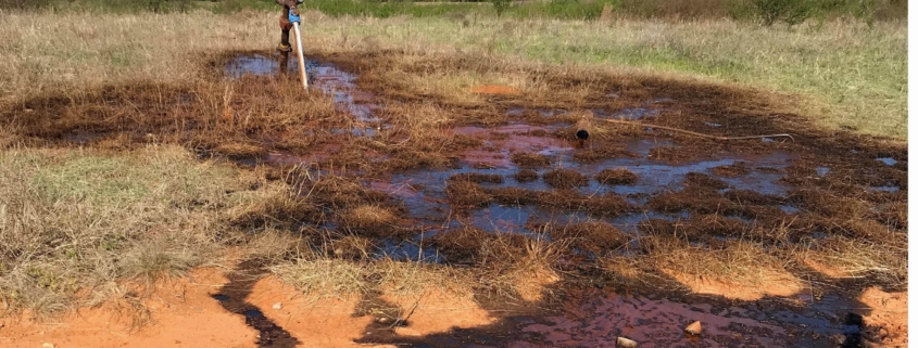
Lithochimeia was retained to investigate complaints of strong hydrocarbon odors from a spring on in south-central Oklahoma.  

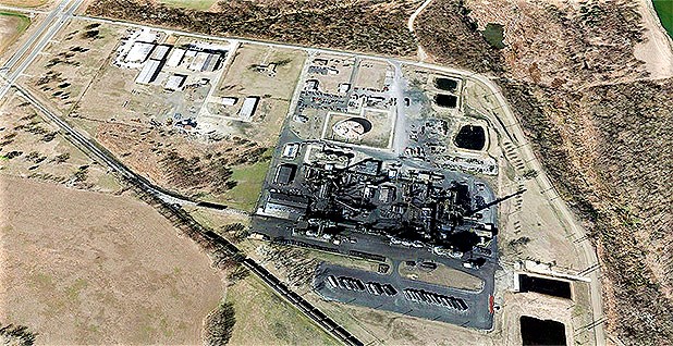
Initial sampling indicated the presence of hydrocarbons in waters flowing from the spring after larger rainfall events.   Pipelines transporting hydrocarbons traversed the property up-gradient from the spring that exhibited hydrocarbon odors.  Lithochimeia conducted a Resistivity Survey to examine the region between the pipelines and the spring for evidence of a pathway existed between the pipelines and the spring.  The Resistivity Survey involved obtaining data from forty north-south transects between the pipelines and the spring.

Electrical current was injected into the subsurface via the electrodes of the array and the resulting electrical activity at the surface was measured and interpreted to produce images representing the electrical properties of the subsurface.

The image resulting form the survey revealed potential subsurface transport pathways between the pipelines and the spring.  The karst geology of the area and diagonally oriented faults were visible as highly resistive cavernous porosity as well as clay and silt filled porosity in the subsurface. 

This 2-D rendering was mapped in 3-D to better visualize the subsurface geometry of the potential transport pathway.

Monitoring wells were installed to both confirm the results of the resistivity survey and to provide access to groundwater for sampling.

Groundwater sampling revealed hydrocarbon signatures similar to those found at the spring.

Widespread Salt Contamination Mapped on 15,000 Acre Ranch

Lithochimeia was retained to investigate current and historic saltwater releases on a large ranch in northeast OK . 

Review of air photos showed numerous areas potentially impacted by salt contamination on the ranch.

Lithochimeia conducted frequency domain electromagnetic (EM) Terrain Conductivity Surveys using a Geonics EM-31-MK2 ground conductivity meter over areas potentially contaminated by saltwater in areas surrounding tank batteries, pumping units, flowline routes, and areas of visible surface damage.  EM Surveys use the principle of electromagnetic induction to measure the conductivity of the subsurface based on soil electrical properties and chemistry of pore fluids.  EM Surveys do not require ground contact and therefore allow rapid data acquisition.   Data can be processed and viewed in near real time.

In all, over 2 million square meters (540 acres) of surface area was surveyed using the EM-31-MK2 ground conductivity meter.  This was accomplished in in less than four weeks because of the ability to rapidly acquire data this geophysical method provides.

Results of the Terrain Conductivity Survey indicated probable widespread contamination of large portions of the ranch by high salinity produced water. The results of the Terrain Conductivity Survey were then confirmed by soil and water sampling and laboratory analysis.

Characterization of contamination this widespread through air-photo analysis, on-ground visual inspection and direct sampling alone would require collecting hundreds of samples and would be very expensive. When applicable, modern geophysical methods provide cost-effective and time-efficient solutions for projects requiring both large amounts of information while maintaining high data density.

Geophysical Investigation Uncovers Hidden Contamination

Lithochimeia was retained to investigate high salinity liquids that had pooled on the surface of a private landowner’s property in Hughes County, Oklahoma.  Lithochimeia was tasked to characterize the extent of contamination and identify the potential source.

Client interviews revealed that a large diameter plastic pipe had been recently installed to transport frac water and flowback water. Over a portion of the property, this line was located adjacent to a steel line carrying natural gas.

A Terrain Conductivity Survey was planned and executed using Geonics EM-31-MK2 over the impacted area as well as the surrounding surface.  Electromagnetic (EM) Surveys use the principle of electromagnetic induction to measure the conductivity of the subsurface based on soil properties and chemistry of pore fluids.  EM Surveys do not require ground contact and therefore allow rapid data acquisition.   Data can be processed and viewed in near real time.

The data obtained was processed in the field, and the resulting contoured map of terrain conductivity showed that the EM Survey clearly imaged the location of the steel gas line and the area of elevated conductivity associated with the pooled saltwater.

the resulting contoured map of terrain conductivity also showed an detached and unexplained area of high conductivity to the west of the original focus of the survey.  As the result , the the survey area expanded to determine the extent and nature of the d unexplained area of high conductivity observed in the original survey.

The expanded EM-31 Survey produced a contoured terrain conductivity map that displayed a large plume of conductive material in the subsurface apparently emanating from the vicinity of the pipeline northwest of the original survey focus.  The data suggested a breach of the plastic line that had been undetected until the EM-31 Survey was conducted and processed. 

Relying exclusively on soil sampling and visual observation would not have been able to detect this subsurface plume of conductive fluids.  The high data density and efficiency of the EM-31 Terrain Conductivity Survey allowed for a larger area to be rapidly characterized.  Early detection of salt contamination will reduce injury to soil and ground water and reduce remedial costs for the responsible party.

Lithochimeia Presents Poultry Waste Papers at the 2009 International Symposium on Environmental Science and Technology in Shanghai, China

News 01

Bert Fisher and Larry Hight presented research papers concerning poultry waste disposal and pollution in the Illinois River Watershed at the 2009 International Symposium on Environmental Science and Technology held at the Songjiang Campus of Donghua University in  Shanghai, China,  June 2-5, 2009 (http://www.isest.com.cn/).  
Fisher, J. B., R. L. Olsen, F. M. Soster, B. Engle and M. Smith. 2009. The history of poultry waste contamination in the Illinois River Watershed as determined from sediment cores collected from Tenkiller Ferry Reservoir (Oklahoma, United States) In: Progress in Environmental Science and Technology, Volume II, Part B. Proceedings of the 2009 International Symposium on Environmental Science and Technology, Shanghai, China, June 2-5, 2009, Shengcai Li, Yajun Wang, Fengxia Cao, Ping Huang and Yao Zhang, eds., Science Press, Beijing, P. R. China, pp 1222-1237. (ISEST01.pdf)

news 02

Fisher, J. B., R. L. Hight, R. van Waasbergen, B. Engle and M. Smith. 2009. Estimates of the mass generated, disposal timing and the spatial distribution of disposal sites within the Illinois River Watershed (Oklahoma and Arkansas, United States). In: Progress in Environmental Science and Technology, Volume II, Part B. Proceedings of the 2009 International Symposium on Environmental Science and Technology, Shanghai, China, June 2-5, 2009, Shengcai Li, Yajun Wang, Fengxia Cao, Ping Huang and Yao Zhang, eds. , Science Press, Beijing, P. R. China, pp 1238-1247. (ISEST02.pdf)Lithochimea Presents Research Compilation at 2009 International Petroleum & Biofuels Environmental Conference in Houston, TX.

Bert Fisher presented a paper entitled, Using Multiple Soil Salinity Assessment Methods in the Development of Geochemical and Geophysical Salt Contamination Maps for Use in Litigation, at the 16th Annual International Petroleum & Biofuels Environmental Conference held in Houston, TX, November 3-5, 2009 (For a full agenda for all papers presented at the 16th Annual International Petroleum & Biofuels Environmental Conference see http://ipec.utulsa.edu/Conf2009/Agenda%2010-3-09/Agenda09.htm).

Fisher, J. B. 2009. Using Multiple Soil Salinity Assessment Methods in the Development of Geochemical and Geophysical Salt Contamination Maps for Use in Litigation, International Petroleum & Biofuels Environmental Conference, Houston, TX, November 3-5, 2009, Abstract. (IPEC2009.pdf)

Lithochimea Presents Case Studies at 2010 International Petroleum & Biofuels Environmental Conference in San Antonio, TX.

Bert Fisher and Kerry Sublette presented a series of case studies illustrating the use of various techniques to characterize the vadose zone migration of oilfield brine contamination at the 17th Annual International Petroleum & Biofuels Environmental Conference.  The paper demonstrated the use of visual observations, geophysical measurements and the chemistry of soil samples in determining the source and extent of oilfield brine contamination at real-world sites in Oklahoma and Kansas.

Fisher, J. B. and K. L. Sublette. 2010. Case Studies of Surface and Vadose Zone Migration of Oilfield Brine Contamination. 2010 17th Annual International Petroleum & Biofuels Environmental Conference San Antonio, TX – August 30 – September 2, 2010  

PRESENTATION)

(Full Agenda: for the 17th Annual International Petroleum & Biofuels Environmental Conference see http://ipec.utulsa.edu/Conf2010/2010agenda.html)

Lithochimeia Presents Study of Poultry Waste Marker Constituents in Edge of Field Runoff within the Illinois River Watershed at the 2010 Governor’s Water Conference and Oklahoma Water Research Symposium in Norman, OK.

Bert Fisher presented a research paper concerning the inorganic chemical markers in poultry waste and how the presence and relative abundance of those markers link the chemistry of water running off poultry waste applied fields to poultry waste and poultry waste contaminated soil 

Smolen, M., J. B. Fisher and R. Olsen. 2010. Poultry waste marker constituents in edge of field runoff samples from the Illinois River Waterhsed.  Oklahoma Governor’s Water Conference and Water Research Symposium, Norman, OK  (October 26-27, 2010) 

(ABSTRACT / PRESENTATION)

( For all 2010 Oklahoma Water Research Symposium Abstracts see:  http://environ.okstate.edu/OKWATER/abstracts_all.asp).  

Lithochimeia Presents 2011 Poster on Lake Tenkiller Sediment Contamination

KEY SCIENCE RELIED ON IN POULTRY LITIGATION

FEATURED IN  Journal of Applied Microbiology

Roger Olsen (CDM), Bert Fisher and Fred Soster (DePauw University) presented a poster at the 6th International Conference on Remediation of Contaminated Sediments 
demonstrating the use of principal components analysis and sediment geochronology to demonstrate the relationship between the chemistry of Lake Tenkiller sediments and the history of poultry waste disposal within the Illinois River Waterhshed.

Olsen, R. L., J. B. Fisher and F. M. Soster. 2011.  Evaluations of the sources of contamination in sediment cores form Tenkiller Reservoir (Oklahoma, U.S.A.).  6th International Conference on Remediation of Contaminated Sediments, New Orleans, Feb 7-10, 2011.

 (2011 Battelle POSTER  2011 Battelle ABSTRACT)

Final Program:  http://www.battelle.org/conferences/sediments/pdfs/finalprogram.pdf).

Oil and Gas Contamination in Osage County, Oklahoma

In 2000, Osage County rancher and landowner, Don Quarles, brought suit against oil and
gas producers for historical and ongoing crude oil and saltwater pollution damage to his
land and groundwater.

Lithochimeia reviewed hundreds of well files, well logs, historic air photos, soil survey
data , geologic reports and water quality reports to establish evidence of historic releases
of oil and saltwater. In addition, Lithochimeia conducted extensive on-site inspections of
nearly one hundred well sites and, as appropriate, collected soil samples for salinity and
hydrocarbon analysis. Lithochimeia also executed numerous terrain conductivity surveys
to establish the spatial extent of salt pollution ad heavily contaminated sites. During the
course of this litigation, Lithochimeia prepared a series of expert reports and provided
deposition testimony and testimony at a jury trial in the United States District Court for
the Northern District of Oklahoma regarding the pollution injury, its causation and
monetary damage to Quarles’ land.

The jury entered a verdict for Quarles and awarded monetary damages.

Carbon Black Contamination in Ponca City, Oklahoma

In 2004 the Ponca Tribe of Indians filed suit against Continental Carbon Company, owned by the Koo family of Taiwan, for damages from carbon black emissions from its Ponca City-based factory.

Lithochimeia provided technical counsel to Plaintiff’s attorneys regarding existing sampling data and assisted plaintiffs in conducting sampling in an around the Continental Carbon Company site. Other tasks undertaken by Lithochimeia included establishing the precise latitude and longitude of hundreds of addresses in Ponca City, producing a large variety of custom maps and displays including maps of plume concentrations of particulates based on air quality modeling and preparing an expert report linking the production of carbon black at the Continental Carbon Company site to carbon black found on surfaces outside the boundaries of the Continental Carbon Company site. A second expert report was prepared in rebuttal to certain statistical and chemical assertions made by a one of the Defendant’s experts.

This matter is in active litigation and is scheduled for trial in November 2008.

Poultry Waste Contamination of Surface Water in Northeastern Oklahoma

A large and growing numbers of broiler chickens and other poultry are produced within northwestern Arkansas and northeastern Oklahoma. Historically, wastes produced by poultry have been land disposed by simple broadcast spreading near where such wastes are generated. Because of the industrial farming practices employed in the growing of poultry, these wastes contain very high levels of phosphorus, and application of these wastes to land adds phosphorous far in excess of the amount required to grow crops. Once applied to the land the phosphorous from the wastes can and does move from the soil to surface waters in runoff. Phosphorus is the element most likely to limit algae growth in lakes and reservoirs. The excessive growth of algae in lakes and reservoirs results in a number of problems including, the production of carcinogens when the water is disinfected prior to distribution, taste and odor problems from algal production of geosmin and 2-methyliosborneol, anoxia in bottom waters and aesthetics issues.

In 2001, the City of Tulsa filed suit against some of the largest poultry producers in the nation including Tyson, Simmons and Cargill in the Northern District of Oklahoma. The City alleged that the Defendants’ growers polluted Lakes Eucha and Spavinaw, from which Tulsa draws approximately half of its water supply, with 170 million pounds of phosphorous each year as the consequence of the land disposal of poultry wastes. In July 2003, The City of Tulsa and the Tulsa Metropolitan Utility Authority reached a court approved settlement in City of Tulsa v. Tyson, et al. with Tyson and other large poultry producers regarding nutrient management practices to be employed within the Spavinaw Creek Watershed. In their lawsuit the City of Tulsa and the Tulsa Metropolitan Utility Authority contended that land disposal of poultry waste within the Spavinaw Creek watershed had resulted in elevated levels of phosphorous in the water supply reservoir lakes, Lake Eucha and Lake Spavinaw, fed by Spavinaw Creek. The settlement agreement stated that future disposal of poultry waste within the Spavinaw Creek Watershed would be managed a Phosphorus Index that would be specifically developed for this watershed. 

After the settlement agreement was executed, the Tulsa Metropolitan Utility Authority (TMUA) and the City of Tulsa retained Lithochimeia to provide technical counsel and expert witness services regarding phosphorous indices proposed by both TMUA and the Defendants. Lithochimeia has also provided ongoing technical counsel to TMUA and the City of Tulsa regarding reports prepared concerning water quality in Lakes Eucha and Spavinaw and in Spavinaw Creek and its tributaries. Most recently, Lithochimeia produced an expert report concerning the currently employed phosphorus index being used to manage poultry waste disposal within the Spavinaw Creek watershed. This expert report recommended a number of improvements to this phosphorus index.

In June 2005 the State of Oklahoma filed a lawsuit (State of Oklahoma v. Tysons Foods, Inc. et.al.) in the Northern District of Oklahoma against some of the nation’s largest producers of chickens, turkeys and eggs, including some out-of-state producers that alleged contamination of the Illinois River and Lake Tenkiller. The State of Oklahoma contended that land disposal of poultry waste within the Illinois River watershed had resulted in elevated levels of phosphorous, bacteria and other poultry waste constituents in the Illinois River and its tributary streams, and that such pollution was a threat to the environment and human health. The State’s complaint alleges violations of state and federal nuisance laws, trespass, as well as other violations of state environmental regulations. The State also seeks to recover the costs that it has had to incur, and will incur, to respond to the pollution under CERCLA.

The State of Oklahoma retained Lithochimeia at the beginning of the lawsuit to provide technical counsel, technical management, field sampling and expert witness services, including two depositions, testimony at a preliminary injunction hearing and just over six days of trial testimony. Lithochimeia developed information regarding poultry industry waste generation and disposal practices, fate and transport of nutrients and metals from poultry waste application fields to surface and ground water within the Illinois River Watershed and developed a model of the historical impact of poultry waste disposal on the Illinois River Watershed from geochemical and geochronological study of Lake Tenkiller sediments.

These matters are still in active litigation.